Ladakh At A Glance
Located North
of the Indian Himalayas, Ladakh is sandwiched between what is now Pakistan in the West and Chinese-ruled Tibet in the East. It is a land of high passes, and is often described
as "little Tibet" - because culturally it has more in common with Tibet than the rest of India. It is a land like no other - a high altitude desert cradled by
the Kharakoram and the Great Himalayan Ranges,
it lies astride two others, the Ladakh range and the Zanskar Range,
at altitudes ranging from 3000 m to 7672 m. Roads and trekking trails cross these mountain barriers through passes at an average
elevation of more than 5000 m - the highest highway in the world crosses the Ladakh Range at the 5578 Meters high Khardung-la.
The road journeys
to Ladakh. Starting at Manali is an unforgetful experience; crossing over a series of high passes, topped by the 5360 m high
Tanglang-la - it is an adventure, offering spectacular scenery.
Manali to Leh road map
Regions Ladakh comprises of the Indus Valley, Nubra Valley, Changthang – Rupshu, and Zanskar.
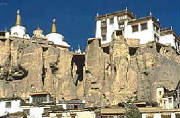
The Indus Valley - at an average elevation of 3500 m is sand-witched between the Zanskar Range on its South and the Ladakh Range on its North, This is the geographical backbone, and the historical
heartland of Ladakh. All major sites connected with its dynastic history are here, starting with Leh, the capital city. The
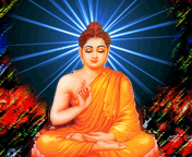
bulk of the population resides along the Indus. Its main attraction are the numerous Buddhist monasteries, quaint
villages, fairs , festivals and bazars. Air and road communications converge at Leh..
Down the Indus, on the route
to Balistan, at an altitude of 2600 M, in located the Dha-Hanu Area comprising a handful of villages growing rich crops pf
vegetables and fruits. Dha-Hanu is of interest to visitors because of the miniscule community called the Drok-pa. They are
Buddhist - but also worship nature gods and spirits. Of Aryan origin, they are the last remnants of the Dards. Numbering a
few thousands, they have preserved their racial purity through centuries. Located 162 kms from Leh, only two of the five Drok-pa
villages are open to Tourists.
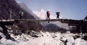
The Markha Valley - an offshoot of the Indus
lies close to Leh but is separated by the Stok Kangri Ridge rising upto the 6700 m high Konglacha peak. Variety of terrain,
cultural content, and isolation from road traffic, makes it a popular trekking circuit.
 The Nubra Valley - lies 200 Kms by road, North of
Leh, across the Ladakh Range. To reach there you have to undertake the highest road journey, over the
Khardung -la at 5578 Meters. The main population centers are Deskit and Hunder. Nubra is well cultivated and fertile, With
plenty of water and a hospitable altitude of around 3000 m, it has the best climate in Ladakh, and Because of this the Nubra
was the main staging post for caravans traversing from Kashmir,
Ladakh and Tibet to Central Asia. Its main attractions are its climate, greenery, and views of glaciers and peaks of the
Kharakoram, enchanting valleys and villages, Buddhist Gompas, Hot Springs. Double hump camels-remnants of the trade route days, enable an interesting
camel safari. Road building has taken its toll. The heavy military and tourist traffic has disturbed its tranquility. Yet
a jeep safari to Nubra, is a unique experience.
|
 |
|
The Uplands
of the Rupshu and Tso Morari Lake - are located about 240 Kms, South East of Leh, The Rupshu is formed by the drainage
of the Zanskar Range, transforming it into bare rolling many hued hills divided by open high altitude valleys - called the
" changthang". It has many high passes and pastures, with both fresh and brackish water lakes. The main attractions are the
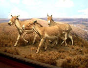
28 Kms long Tso - Morari lake at an altitude of 4000 M, spectacular views, wildlife - the Kyang, or the Tibetan wild Ass,
snow leopard, foxes, marmots, exotic birds like bar headed Goose, black necked crane, and other migratory birds, are found
here.
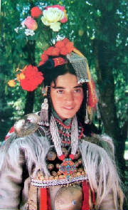
This is also the home of the nomadic herdspeople, called the Chang -pa. There
are few small villages. The best way to experience the Rupshu is to traverse it whilst trekking - and for the more adventurous
cross over to Spiti, across the Great Himalayas, over the 5578 m high Parang-la pass.
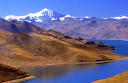
North of the Rupshu Valley, across the 5475 m high Chang-la pass, 154 kms East
of Leh the upland plateau continues to, the Pangyong Lake at an altitude of 4300 M. The lake is 130 kms long, and is bisected
by the border between India and Tibet. It is set amidst the spectacularly colored mountains, with snowcaps
and glaciers of the Changchenmo Range in the background. There are a few scattered Chang-pa hamlets.
Zanskar – lies to the South of Ladakh Comprising of a number of small interlocking valleys, the region is located between
the Zanskar Range to its Northand the Great Himalayas to its South. Mountain barriers
to the East and West complete its isolation.
The Valleys of Stod and Lunak form Zanskar. Its small population lives in villages
clustered around the administrative Center of Padum,
and along the Zanskar River and its tributaries. Zanskar is linked to the outside world by
a spectacular mountain road originating from Kargil in the Saru Valley and crossing over the 4450 meters high Pensi la. The road is open for traffic only for a limited period from
July to early October. A number of challenging treks start from Padum, over the ancient trade routes, leading to Darcha on
the Manali-
Leh Highway, to Lamayaru on the Leh-Kargil Highway, and To Leh via the Markha Valley. All these trek cross over high passes over 5000 meters in altitude.
Permit and Passpot
: Tourist don't require permit for Leh, however, all
foreigners are required to be registered at Drass, Rumtse and Serchu if they are travelling overland. Those traveling by air
get themselves registered at airport. Tourists are required to get permit for restricted areas like Tsomoriri, Tsokar and
Pangong Lakes, Dhahanu and Nubra Valley, which can be obtained from District Magistrate, Leh, through
T.B.I. Travel office at Leh.
Road Distences
:Srinagar-Leh 434 Km;Manali-Leh 473 Km ;Srinagar-Kargil 204 Km ;Delhi-Leh 1047 Kms;
Leh-Kargil 234 Km ;Kargil-Padum (Zanskar) 240 Km ;Leh-Deskit (Nubra Valley) 118 Kms.
Air Travel: Indian Airlines www.indian-airlines.nic.in operates regular flights to Leh from Delhi. Four flight in
a week from Jammu, once in a week from Chandigarh and twice from Srinagar. Jet Airways
www.jetairways.com operates daily flights between Leh to Delhi
|
|